WLX GPXLister 4 TC 2.8.2
Описание
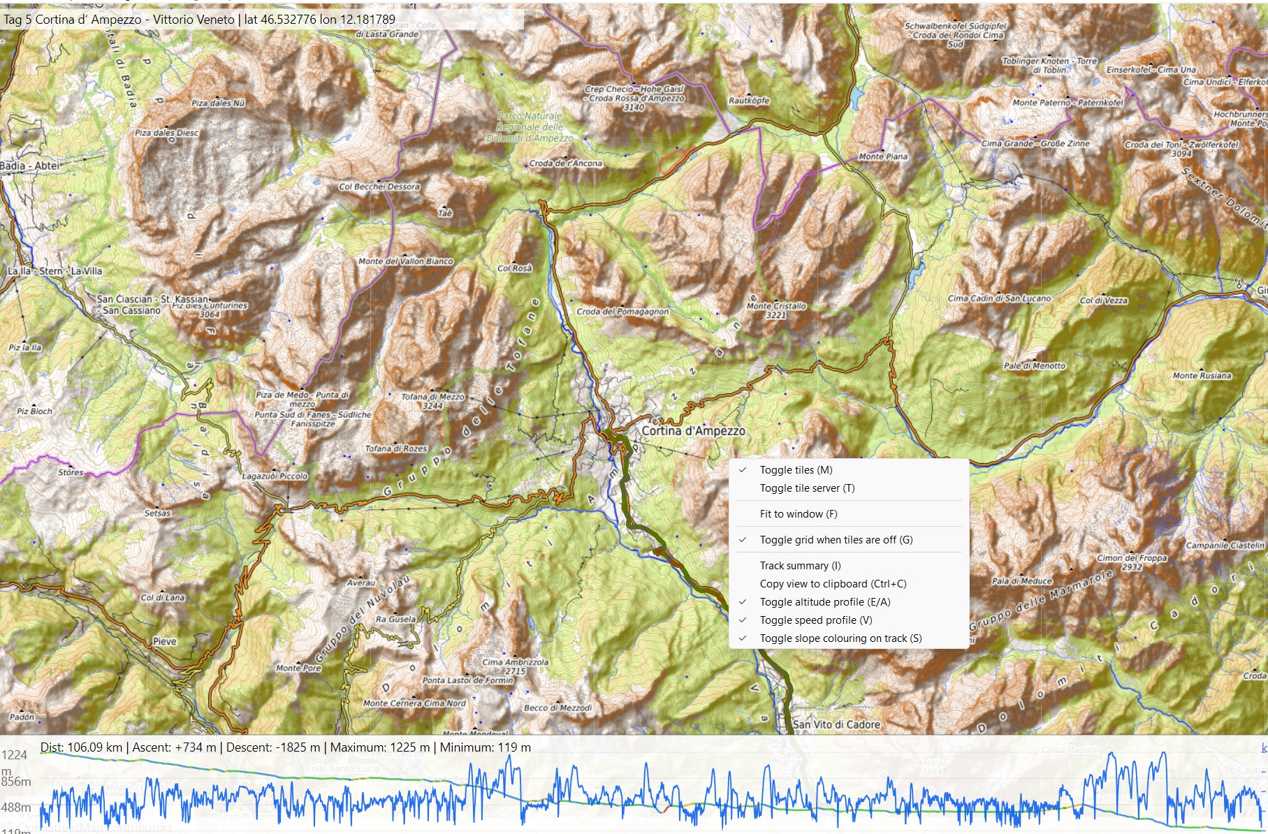
GPXLister — плагин просмотрщика Total Commander для просмотра файлов GPS-треков. Он отображает треки GPX, FIT, KML и KMZ на интерактивной карте с отрисовкой через Direct2D и 3D, тайлами карт, спутниковым режимом, профилями высоты и скорости, выбором нескольких треков, сводками по трекам и экспортом текущего вида в буфер обмена.Требуется Windows 10 или новее. Для поддержки FIT/KML/KMZ рядом с плагином должны находиться входящие в комплект инструменты-конвертеры.
Github: https://github.com/jumpifequal/TotalCommander-GPXLister
Что нового
→ v2.8.2 - Minor ahestetic adjustments
• Added: new ini setting for hovering circle radius in logic pixels (DPI adapted) `hoverCircleRadius`, default value to 6.0. Valid range 2.0 - 30.0
• Fixed: red 2 px outline with 50% transparent white fill.
• Fixed: existing 2D size retained: 6 logical-pixel radius.
• Fixed: 3D now uses matching 6/2 CSS-pixel dimensions; CSS pixels and Direct2D DIPs scale with monitor DPI.
• Fixed: current 2D map center and zoom are now preserved when entering 3D.
• Fixed: terrain camera finalization remains active to avoid regressing hover alignment.
→ v2.8.1 - Reliable 3D hover synchronisation
• Added direct track-point hovering in the 3D view: moving over a 3D track updates the marker and altitude/speed profile guide, and the active hover point stays synchronised when switching between 2D and 3D.
• Fixed the 3D hover marker appearing only after a resize or camera drag; the mouse, marker, and altitude/speed profile guide are now aligned as soon as the 3D view opens.
• Kept the 3D marker and altitude/speed profile guide synchronised when hovering a profile or using downsampled tracks.
• Fixed stale or duplicate hover indicators after switching views or moving the pointer outside the 3D view.
• Fixed 3D hover timestamps so they match the source GPX date and local time shown in 2D.
• Kept the 3D marker fully visible across camera angles.
• Prevented isolated terrain-tile download failures from unexpectedly closing an otherwise working 3D session.
→ v2.8 - 3D map view
• Added an optional 3D view (D) context-menu action and D shortcut while keeping flat 2D as the startup view; the numeric 3 key remains available to Total Commander for Lister mode switching.
• Added 3d_model=1 for perspective rendering and 3d_model=2 for real DEM terrain; a missing or invalid setting is repaired to 2.
• Added free Terrarium terrain as the default provider and MapTiler Terrain RGB support through an API key.
• Kept track names, distance/elevation statistics, cursor elevation/speed/time, waypoints, track filtering, slope colouring, altitude/speed profiles, and profile-to-map point selection available in 3D.
• Added Google Earth-style combined navigation: drag/wheel/keyboard pan and zoom, right-drag or Ctrl/Shift+left-drag rotation/pitch, N north-up, U top-down, and F fit.
• Added safe automatic fallback to flat 2D when WebView2, local assets, or the terrain provider fail.
• Distribution now includes the local MapLibre web assets required by both 3D modes; only the Microsoft WebView2 Evergreen Runtime may need separate installation.
• Fixed 3D shortcut routing (including T/Shift+T) and added reliable Ctrl/Shift+left-drag rotation and pitch.
• Fixed black patches caused by overlapping invisible hover targets on dense 3D tracks.
• Added bounded 3D tile/worker caches and release of the 3D renderer when returning to 2D.
→ v2.7.1 - Reverse map style cycling
• Added Shift+T to cycle backward through the configured map styles, making Standard/Topo comparisons quicker when those styles are adjacent in mapTypeOrder.
• Updated distribution metadata to version 2.7.1.
→ v2.7 - Configurable map styles
• Added mapTypeOrder to control the startup map style, the T keyboard cycle, and the map context-menu order.
• Added named map style endpoints: standardTileEndpoint, satelliteTileEndpoint, and topoTileEndpoint.
• Replaced the context-menu tile-server toggle with a Map style submenu for direct style selection.
• Added Add track file... to append GPX/FIT/KML/KMZ files temporarily to the current view using the existing multi-track sidebar.
• Fixed tile-cache worker state so WinINet download handles remain thread-local during parallel tile downloads.
• Preserved legacy tileEndpoint as the old alias for the standard map style.
• Added safe mapTypeOrder repair for unknown, duplicate, empty, and backward-compatible standard-only configurations.
• Updated distribution metadata to version 2.7.
→ v2.6 - Clipboard copy and persistent speed profile
• Added Ctrl+C, Ctrl+Ins, and standard Lister copy support to copy the current Lister view to the clipboard as PNG, also available from the map context menu.
• Added persistent showSpeedProfile INI storage for the speed profile toggled with V or the context menu.
• Updated distribution metadata to version 2.6.
• Changed default tile rendering to opentopomap with hill shadows
• Added tiles topo map server rendering samples
• Added: new ini setting for hovering circle radius in logic pixels (DPI adapted) `hoverCircleRadius`, default value to 6.0. Valid range 2.0 - 30.0
• Fixed: red 2 px outline with 50% transparent white fill.
• Fixed: existing 2D size retained: 6 logical-pixel radius.
• Fixed: 3D now uses matching 6/2 CSS-pixel dimensions; CSS pixels and Direct2D DIPs scale with monitor DPI.
• Fixed: current 2D map center and zoom are now preserved when entering 3D.
• Fixed: terrain camera finalization remains active to avoid regressing hover alignment.
→ v2.8.1 - Reliable 3D hover synchronisation
• Added direct track-point hovering in the 3D view: moving over a 3D track updates the marker and altitude/speed profile guide, and the active hover point stays synchronised when switching between 2D and 3D.
• Fixed the 3D hover marker appearing only after a resize or camera drag; the mouse, marker, and altitude/speed profile guide are now aligned as soon as the 3D view opens.
• Kept the 3D marker and altitude/speed profile guide synchronised when hovering a profile or using downsampled tracks.
• Fixed stale or duplicate hover indicators after switching views or moving the pointer outside the 3D view.
• Fixed 3D hover timestamps so they match the source GPX date and local time shown in 2D.
• Kept the 3D marker fully visible across camera angles.
• Prevented isolated terrain-tile download failures from unexpectedly closing an otherwise working 3D session.
→ v2.8 - 3D map view
• Added an optional 3D view (D) context-menu action and D shortcut while keeping flat 2D as the startup view; the numeric 3 key remains available to Total Commander for Lister mode switching.
• Added 3d_model=1 for perspective rendering and 3d_model=2 for real DEM terrain; a missing or invalid setting is repaired to 2.
• Added free Terrarium terrain as the default provider and MapTiler Terrain RGB support through an API key.
• Kept track names, distance/elevation statistics, cursor elevation/speed/time, waypoints, track filtering, slope colouring, altitude/speed profiles, and profile-to-map point selection available in 3D.
• Added Google Earth-style combined navigation: drag/wheel/keyboard pan and zoom, right-drag or Ctrl/Shift+left-drag rotation/pitch, N north-up, U top-down, and F fit.
• Added safe automatic fallback to flat 2D when WebView2, local assets, or the terrain provider fail.
• Distribution now includes the local MapLibre web assets required by both 3D modes; only the Microsoft WebView2 Evergreen Runtime may need separate installation.
• Fixed 3D shortcut routing (including T/Shift+T) and added reliable Ctrl/Shift+left-drag rotation and pitch.
• Fixed black patches caused by overlapping invisible hover targets on dense 3D tracks.
• Added bounded 3D tile/worker caches and release of the 3D renderer when returning to 2D.
→ v2.7.1 - Reverse map style cycling
• Added Shift+T to cycle backward through the configured map styles, making Standard/Topo comparisons quicker when those styles are adjacent in mapTypeOrder.
• Updated distribution metadata to version 2.7.1.
→ v2.7 - Configurable map styles
• Added mapTypeOrder to control the startup map style, the T keyboard cycle, and the map context-menu order.
• Added named map style endpoints: standardTileEndpoint, satelliteTileEndpoint, and topoTileEndpoint.
• Replaced the context-menu tile-server toggle with a Map style submenu for direct style selection.
• Added Add track file... to append GPX/FIT/KML/KMZ files temporarily to the current view using the existing multi-track sidebar.
• Fixed tile-cache worker state so WinINet download handles remain thread-local during parallel tile downloads.
• Preserved legacy tileEndpoint as the old alias for the standard map style.
• Added safe mapTypeOrder repair for unknown, duplicate, empty, and backward-compatible standard-only configurations.
• Updated distribution metadata to version 2.7.
→ v2.6 - Clipboard copy and persistent speed profile
• Added Ctrl+C, Ctrl+Ins, and standard Lister copy support to copy the current Lister view to the clipboard as PNG, also available from the map context menu.
• Added persistent showSpeedProfile INI storage for the speed profile toggled with V or the context menu.
• Updated distribution metadata to version 2.6.
• Changed default tile rendering to opentopomap with hill shadows
• Added tiles topo map server rendering samples